Walking and hiking
in the mountains in Radstadt
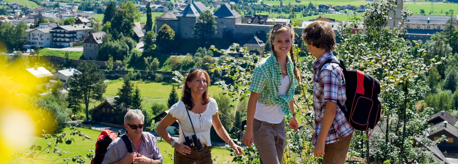
Family walking holiday in the heart of the Salzburger Land
Active summer holiday with extensive walks for everyone


The Family Hotel Taxerhof nestles gently in the green valley floor and makes an ideal base for lovely walks in the picturesque mountain landscape of the iSalzburger Sportwelt. To the north the Dachstein and to the south the Radstädter Tauern – a walking paradise for beginners, pleasure walkers and experieced hikers. Well-marked paths lead straight from the hotel through gentle forests, over lush, green meadows to clear mountain lakes and impressive mountain peaks. Recharge your batteries in the mountains around Radstadt and experience nature up close.
- Well-marked and cleared walking routes
- Mountain huts open for refreshments offering home-made specialities, hotel’s own mountain hut in Zauchensee
- Salzburger Almenweg (long-distance trail) leads through Radstadt (total of 350 km in length, from the Tennengebirge mountains over the Tauern to the Dachstein)
- Popular hike to the Bürgerbergalm on the Rossbrand (1.768 m)
- Weekly guided walks – meeting-point at the Radstadt Sports Centre
- Radstädter Wanderbus – discount with the Salzburger Sportwelt Card
Hiking and nordic walking with the whole family – easy trails for all ages
A family holiday in the mountains makes kids faces light up. Surrounded by colourful nature there’s plenty to explore. – jump over little streams, watch butterflies and bees, build a stable with moss and pine cones and collect juicy red berries. Walks and hikes on gentle paths along blooming meadows and through fairy-tale forests are memorable experiences for children. Start a great walk right from the Family Hotel Taxerhof.
- Family Hotel Taxerhof – ideal base for walks in the Salzburger Sportwelt
- Römerweg towards Untertauern to the Wildlife Park, approx. 2.5 hours
- Easy walks to Altenmarkt and back along the Enns Cycle Path, approx. 1.5 hours
- Hike up the Rossbrand to the Bürgerbergalm
- Circular walk Kaiser promenade, approx. 1.5 hours
- Themed walks in Radstadt


Mountaineering and climbing in the Salzburger Sportwelt region


The wide variety of alpine trails, hiking paths and climbing routes of all levels of difficulty in the Salzburger Sportwelt attract keen climbers and mountaineers. Experienced alpinists can try out to sheer rock faces of the imposing Dachstein and Hochkönig mountain. Whether as a group or a family – a visit to the nearby high ropes courses is great fun. The indoor climbing centre in Wagrain, the largest in Salzburg, is suitable for beginners, all-rounders, youths and families.
- Outdoor climbing possibilities: Dachstein, Hofpürgelhütte, Hochkönig, Tennengebirge
- A number of secured routes in the Salzburger Sportwelt
- Indoor climbing centre in Wagrain with 220 m2 climbing area
- Climbing trails, sports climbing, alpine climbing
- Adventure courses and caving tours
- High ropes courses in Flachau and Altenmarkt

The Taxerhof presents – the 15 best hiking tours around Radstadt
Rossbrand - Radstadt's home mountain
Not without good reason the Rossbrand (1,768 m) counts amongst one of the most beautiful mountains with spectacular views in the Eastern Alps. Its peak offers a 360° panoramic view of 150 well-known alpine peaks – from the Dachstein to the north, the Tennengebirge, Hagengebirge and Grossglockner as well as the Radstädter and Schladminger Tauern – the splendour of the Alps as far as the eye can see. Eight panorama information boards set in stone around the peak tell you all about the natural landscape and other interesting information.
Level of fitness ![]()
![]()
![]()
![]()
![]()
Technique ![]()
![]()
![]()
![]()
![]()
Variety ![]()
![]()
![]()
![]()
![]()
Scenery ![]()
![]()
![]()
![]()
![]()
Level of difficulty: medium
Ascent: 3:00 hrs
Descent: 2:30 hrs
Lowest point: 851 m
Highest point 1.758 m
Tour desciption
From the post office (bus stop) along the Loreto strasse heading north, cross over the main road on a bridge, behind which the Gardeplatz square is on the left. Carry along the Loreto strasse to the next crossroads, from there straight ahead along the Bürgerberg strasse, at the next junction left in bends to a further fork in the middle of which a forest path leads off up to the Bürgerbergalm. The snack hut on the right, through an extensive wooded belt, crossing a forest track a few times, gently climbing up to the ridge offering splendid views from the Radstädter Hütte and the nearby Rossbrand peak. Right next to the hut the descent leads via Pertill back to Radstadt. Along path no. 461 in a southerly direction through light forest to the mountain road, cross over the road and through the forest to Münzgrub and on further to Rohrmoos. Along the road turn off to the right – cross the road a few times and tangent back to Radstadt. Through the Schloss strasse approx. 800 m to the west back onto the Loreto strasse, the Gardeplatz square and the post office.
Path No.
462
Public transport
Every Monday and Thursday the Wanderbus departs directly from the Taxerhof up to the Rossbrand / Radstädter Hütte / turn-off Gasthof Rohrmoos and Resialm. From there you can reach the peak in about 10 minutes on foot.
You can also drive up the Rossbrand by car. Just 10 minutes on foot from the car park to the peak.
Gnadenalm area - suitable for pushchairs
Vordergnaden – Hintergnaden
Level of fitness ![]()
![]()
![]()
![]()
![]()
Technique ![]()
![]()
![]()
![]()
![]()
Variety ![]()
![]()
![]()
![]()
![]()
Scenery ![]()
![]()
![]()
![]()
![]()
Level of difficulty: easy
Ascent: 25 mins.
Descent: 25 mins.
Lowest point: 1.300 m
Highest point: 1.320 m
Tour description
From Radstadt, coming from Untertauern up towards Obertauern, turn right at the sign for the "Gnadenalmen" Free parking by the Vordergnadenalm (possiblity to drive to the Hintergnadenalm for the less mobile). Walking time to the is approx. 30 through a lovely alpine valley, past streams and grazing animals. This path is very flat and suitable for gentle cyclists, families with small children (also with pushchairs).
Hintergnaden – Johannes Waterfall
Level of fitness ![]()
![]()
![]()
![]()
![]()
Technique ![]()
![]()
![]()
![]()
![]()
Variety ![]()
![]()
![]()
![]()
![]()
Scenery ![]()
![]()
![]()
![]()
![]()
Level of difficulty: easy
Ascent: 40 mins.
Descent: 35 mins.
Lowest point: 1320 m
Highest point: 1400 m
From the Hintergnadenalm a shady path leads through alpine meadows to the impressive Johannes Waterfall. Experience an impressive natural spectacle. Enjoy the splendid view of the approx. 60 m high waterfall or take time to climb up the trail that leads behind the waterfall.
Tip for a refreshment stop for all Gnadenalm walks: Gschwendthofhütte in Hintergnaden
- Large natural children’s playground
- Home-made cheese
- Home-baked bread
- Great selection of cakes
Cable car hiking in Zauchensee
Level of fitness ![]()
![]()
![]()
![]()
![]()
Techniqe ![]()
![]()
![]()
![]()
![]()
Variety ![]()
![]()
![]()
![]()
![]()
Scenery ![]()
![]()
![]()
![]()
![]()
Reach an altitude of 1,900 m quickly and comfortably on the 6-seater Gamskogel I chairlift in Zauchensee and stop for refreshment at the Gamskogelhütte einkehren or start a hiking tour with spectacular views from here. The chairlift in Zauchensee is in operation from June to September from 9.00 am to 4.00 pm every hour on the hour.
Refreshment stop at the Gamskogelhütte in Zauchensee
There’s lots for younger visitors to see and do at the Gamskogelhütte. Right next to the sun terrace there’s a children’s playground with attractions such as the "marmots' cave" or the "water fountains" which kids just love.
Barbecue area at the Gamskogelhütte
Savour amid the mountain backdrop of Zauchensee an unforgettable day at an altitude of 1,900 m at the Gamskogelhütte and barbecue your own lunch. The staff at the Gamskogelhütte will prepare a full picnic basket for you. At the newly-created barbecue area on the terrace of the Gamskogelhütte in Zauchensee you can barbecue for friends and family.
Family tip from Gamskogelhütte – carry on to the Seekarsee Lake
An easy and short walk from the Gamskogelhütte – head up to the Seekarsee Lake, the largest snowmaking reservoir in Europe. Journey on the tractor-train possible.
Hiking tip from the Gamskogelhütte – Rosskopf hiking tour
Walk from the Gamskogelhütte via the Seekarscharte to the Rosskopf (1,929 m). Descend over the Höchalm and the Unterbergalm back to Zauchensee. This tour takes around 3 ½ hours.
Filzmoos Hofalmen - suitable for pushchairs
Level of difficulty ![]()
![]()
![]()
![]()
![]()
Technique ![]()
![]()
![]()
![]()
![]()
Variety ![]()
![]()
![]()
![]()
![]()
Scenery ![]()
![]()
![]()
![]()
![]()
Level of diffiuclty: easy
Ascent: 1 – 1.5 hrs
Descent: 1 -1.5 hrs
Lowest point: 1.057 m
Highest point: 1.297 m
Starting point in the village square in Filzmoos. Follow the well-marked path to the Hofalmen. Walking time approx. 1 – 1.5 hours, altitude difference 240 m
Oberhofalm: Rustic, quaint hut over 300 years old, cosy snugs, sun terrace, farmers' specialities, old water wheel next to the hut
Unterhofalm: "The Adventure Alm", 220 years old, cosy snugs and larger dining areas, sun terrace, farmers' specialities, water wheel
Tip: Enjoy a circular walk from the Oberhofalm via the Almsee lake to the Unterhofalm or in the other direction (walking time approx. 20 mins.) – a perfect tour for families with a gentle gradient, also suitable for small children.
Tappenkarsee Lake
Level of fitness ![]()
![]()
![]()
![]()
![]()
Technique ![]()
![]()
![]()
![]()
![]()
Variety ![]()
![]()
![]()
![]()
![]()
Scenery ![]()
![]()
![]()
![]()
![]()
Level of difficulty: medium
Walking time: Jägersee Lake – Schwabalm 1 hr, Schwabalm – Tappenkarsee Lake 1:45 hrs
Lowest point: 1.007 m
Highest point: 1.557 m
A legendary mountain lake and two mountain huts
The Tappenkarsee Lake is situated in a nature reserve, surrounded by rugged mountain rock faces and gentle pastures and attracts many hikers to its shores on sunny days. The legend surrounding the lake is of the lindworm, which after it was attacked, buried itself in the depths of the lake. Since then it nibbles on the rocks at the edge of the lake – until it has broken through and disaster pours into the valley. However, it appears that the rock face is quite stable and and you can hike up to the Tappenkarsee lake without worrying.
Tour description
From the Jägersee lake car park walk or drive along a flat forest road (toll road) to the Schwabalm. This is the start of the ascent to the Tappenkarsee lake. At first the path leads through light forest, then uphill along steeper bends to the lake. Carry on along the lake until a corrie opens up to another basin. Half way along the Tappenkarsee lake you’ll find the Tappenkarseealm and higher up the Tappenkarseehütte. The Tappenkarsee is situated in a nature reserve and counts as the highest mountain lake in the Eastern Alps.
Tip for families: Enjoy a gentle walk around the Jägersee lake (¾ hr.) – suitable for pushchairs
Twenger Almsee Lake
Level of fitness ![]()
![]()
![]()
![]()
![]()
Technique ![]()
![]()
![]()
![]()
![]()
Variety ![]()
![]()
![]()
![]()
![]()
Scenery ![]()
![]()
![]()
![]()
![]()
Level of difficulty: medium
Ascent: 2 hrs
Descent: 1:45 hrs
Lowest point: 1.600 m
Highest point: 2.100 m
A gem in the Radstädter Tauern with particularly diverse flora
This hike starts in Obertauern, at the small bridge after the car park behind the Jugendheim Schaidberg (1,600 m), along a steep access road, through a swiss pine forest to the Ernstalm (not open to the public 1,869m, ¾ hour). From the Ernstalm carry on walking through scenic mountain pasture nearly passing the newly-built Twengalm. The path leads along winding bends to the idyllic Twengalmsee lake (2.,100 m). A short climb up to the outflow of the lake over an alpine meadow to the left to a high point from which you have a wonderful view of the Schönalmseen lakes in Lungau. Take the same path back to the car park.
Lackenkogel - Lackenalmen
Level of fitness ![]()
![]()
![]()
![]()
![]()
Technique ![]()
![]()
![]()
![]()
![]()
Variety ![]()
![]()
![]()
![]()
![]()
Scenery ![]()
![]()
![]()
![]()
![]()
Level of difficulty: medium
Ascent: 2 hrs
Descent: 1:45 hrs
Ascent to the Lackenalmen: 1 hour
Lowest point: 1.307 m
Highest point: 2.051 m
The Lackenkogel offers a splendid view over the whole of the Enns Valley. The scenery is beautiful at any time of year. In spring you’ll discover the first snow roses, later the alpine roses bloom and in autum the silver thistles.
This tours starts at the Berggasthof Sattelbauer.
Walk along the path no. 73 for approx. 1 hour until you reach the Lackenalm huts (open from mid-June to mid-September). Then carry on along the path no. 73 to the Lackenkogel (2,051 m). Return along the same route.
Refreshment stop: Between Feuersang and Lackenkogel the Lackenalm alpine pasture area lies in an idyllic location. Two mountain huts open to the public, the Hinterkuchelberghütte and the Göttfriedhütte spoil hikers with home-made delicacies. So it’s not just fabulous views that make this hike worthwhile.
Trail of Good Wishes
Level of fitness ![]()
![]()
![]()
![]()
![]()
Technique ![]()
![]()
![]()
![]()
![]()
Variety ![]()
![]()
![]()
![]()
![]()
Scenery ![]()
![]()
![]()
![]()
![]()
Level of difficulty: easy
Circular walk: 1.5 – 2 hrs
Lowest point: 1.002 m
Highest point 1.190 m
This walk along the themed path "Trail of Good Wishes" takes around 1.5 to 2 hours. Parents and children can learn all about the little things nature has to offer, which are often overlooked. In addition to the natural beauty families can also enjoy the peace and quiet.
Over meadows and through forests
The "Trail of Good Wishes" is easily accesible and leads along marked forest and meadows paths. Parents and children can start the walk in the centre towards the church and from there heading towards the motorway. Above the motorway bridge families continue along the themed path "Trail of Good Wishes" which ends at the Pertil farm.
Further details
From here you walk along path no. 73 to the Sattelbauer, back to Flachau along the "Sattelweg". For this detour you need a extra 30 minutes.
Refreshment stop: Sattelbauer
Filzmoos - Aualm - Mahdalm - Sulzkaralm
Level of fitness ![]()
![]()
![]()
![]()
![]()
Technique ![]()
![]()
![]()
![]()
![]()
Variety ![]()
![]()
![]()
![]()
![]()
Scenery ![]()
![]()
![]()
![]()
![]()
Level of difficulty: easy – medium
Total walking time: 4 hrs
Without Mahdalm: 3 hrs
Lowest point: 1.055 m
Highest point: 2.505 m
The mountain huts and the alpine meadows around the Aualm make the heart of any nature-lover beat faster. Centre piece of the landscape is the mighty Bischofsmütze mountain towering over the mountain bowl. Large parts of the south-east face of the mountain broke off in 1993.
From the car park at the Aualm you hike up over grasslands to the imposingly-situated Hofpürglhütte. 10 minutes walk from the Hofpürglhütte you come to the Austriaweg (611) which you follow after a short detour to the hut continuing westwards to the Sulzkaralm. You then come to the wide corried bowl south of the Bischofsmütze. Walking gently up and down hill you head on to the open south and south easterly slopes of the Leckkogel to a rib of swiss pines and along the Austriaweg at the top edge of the Sulzkaralm mountain pastures. Follow this path through a swiss pine belt to a saddle. Behind which you’ll find a wavy grass ridge edged by swiss pine trees. Over the steep and in part crumbly south wall of the Losegg you climb up and down, past the Sulzkaralm to the Mahdalm. From the Sulzkaralm, where they serve tasty, home-made cheeses, a gentle path with a short connecting trail leads back to the Aualm (1 hr.).
If you descend left down the Austriaweg over a grassy basin the route to the Sulzkaralm takes 1 hr. less.
Zauchensee - Tauernkarleitenalm - Gnadenalm
Level of fitness ![]()
![]()
![]()
![]()
![]()
Technique ![]()
![]()
![]()
![]()
![]()
Variety ![]()
![]()
![]()
![]()
![]()
Scenery ![]()
![]()
![]()
![]()
![]()
Level of difficulty: medium
Total walking time: 2.5 hrs
Lowest point: 1.300 m
Highest point: 1.653 m
Take the bus from the Taxerhof to Zauchensee. There’s also plenty of parking spaces.
From the Almdorf Zauchensee a forest road leads to Oberzauchensee – where the cows graze during the summer. Our dairyman Hans-Peter looks forward to your visit to the Taxerhütte!
Carry on along a meadow and forest path to the Tauernkarleitenalm. The good-natured dairyman Michi and his wife Frau Vroni will spoil you with home-made cheese specialities and cakes.
When you’ve recharged your batteries head back down to the Gnadenalm and from there by bus back to the Taxerhof.
Leisure & Wildlife Park in Untertauern
Level of fitness ![]()
![]()
![]()
![]()
![]()
Technique ![]()
![]()
![]()
![]()
![]()
Variety ![]()
![]()
![]()
![]()
![]()
Scenery ![]()
![]()
![]()
![]()
![]()
Level of difficulty: easy
Duration: 1:30 hrs
Lowest pont: 830 m
Highest point: 1.110 m
Turn right from the Taxerhof and follow the cycle path towards Untertauern / Obertauern. The tarmac path leads past the Walchhofgut and a number of farmhouses. Along the Taurach, on a shady gravel track the route leads on further to Untertauern.
Tip: Rent a bike from us and cycle to the Leisure & Wildlife Park in Untertauern!
Kaiserpromenade
Level of fitness ![]()
![]()
![]()
![]()
![]()
Technique ![]()
![]()
![]()
![]()
![]()
Variety ![]()
![]()
![]()
![]()
![]()
Scenery ![]()
![]()
![]()
![]()
![]()
Length: 5,9 km
Duration: 1:45 h
Lowest point: 825 m
Highest point: 934 m
To celebrate the silver wedding anniversary of Kaiser Franz Joseph I. and Kaiserin Elisabeth a "Kaiserlinde" (a linden tree) was planted in 1879 in Radstadt. Its place was in the school garden in front of the Steirertor. In the same year the Kaiser himself visited Radstadt, where during his half-hour stop he was presented with a bouquet of edelweiss. In 1898 the Kaiserpromende was created to celebrate his 50 year jubilee as Kaiser.
The path starts at the sports centre and leads along the Schlossstrasse in towards Schloss Lerchen. At the crossroads to the old main road the Kaiserpromenade leads along the Rupertgasse onto the Schwemmberg. From the Loreto church back onto the footpath. ThepPromenade leads towards the Rossbrandstasse and Dörfl, back onto the Schlossstrasse and to the sports centre.
Car park at the Sports Centre in Radstadt
Hirschwandsteig Trail
Level of fitness ![]()
![]()
![]()
![]()
![]()
Technique ![]()
![]()
![]()
![]()
![]()
Variety ![]()
![]()
![]()
![]()
![]()
Scenery ![]()
![]()
![]()
![]()
![]()
Level of difficulty: medium
Duration: 3.5 hours
Lowest point: 1.330 m
Highest point: 1.802 m
Drive to Obertauern, from the Vordergnaden on towards Hintergnaden. From there carry on on foot. Follow the path to the impressive Johannes waterfall, where the water cascades down from a height of around 60 metres. Behind the waterfall a trail leads to the Felseralm – past rugged rocks, through forests, along alpine meadows to the Südwienerhütte. An impressive natural spectacle and an abundance of flowers await. This trail is at its best in July when the alpine roses are in bloom. From the Südwienerhütte head along a forest track back to the Hintergnadenalm.
Cable car hiking in Obertauern
Level of fitness ![]()
![]()
![]()
![]()
![]()
Technique ![]()
![]()
![]()
![]()
![]()
Variety ![]()
![]()
![]()
![]()
![]()
Scenery ![]()
![]()
![]()
![]()
![]()
Treat yourself to a break and use the Grünwaldkopfbahn for a journey up to the Alm. Enjoy Salzburg hospitality and regional specialities. On the Grünwaldkopfbahn in Obertauern you can travel effortlessly and quickly up to an altitude of 1.970 m Seehöhe, where a spectacular mountain panorama awaits.
Relax by the Grünwaldkopfsee lake or hire one of the new rowing boots and explore this beautiful mountain lake.
Mountain bikes and pushchairs are transported free of charge. Dogs are also permitted. Only in operation in fine weather.
Hiking tip: From the Grünwaldkopfbahn a lovely footpath leads to the Dikt’n Alm.
Family walk along the "Wild Waters path"
Starting point: From Schladming towards Rohrmoos, at the roundabout in Rohrmoos turn left towards Untertal
From Schladming to deep into the Rohrmooser Untertal up to an altitude of 2,600 m leads one of the most unique footpaths in the world. The 14.5 km "Wild Waters“ shows our most precious commodity in all its beauty – quietly glistening, crystal-clear to gushing, in free-fall over the rocks of the Schladminger Tauern. A unique natural spectacle, that was awarded the title of first "National Geographic Footpath“ in 2009.
Along the way there are plenty of places to stop for refreshment offering famous, Styrian hospitality.
Stage 1: Talbachklamm gorge
Start: Schladming – wildly romantic gorge, gently climbing, suitable for pushchairs, also suitable for beginner walkers, walking time one way approx. 50 mins. as circular trail approx. 1 hr.
Stage 2: Water wheel hike
Start: Fire station in Rohrmoos – gentle water hike for sporty parents, even suitable for pushchairs, with interesting information about fauna, flora and "olden times" – walking time one way 1.5 hrs., as circular tour "Untertaler view trail“ 3 – 4 hrs.
Stage 3: Family walk – suitable for pushchairs
Start: Car park Hinker bridge – easy walk all ages along the Untertal stream and over alpine meadows, suitable for pushchairs, themed walk "Wild Waters" – walking time approx. 2.5 hrs.
Stage 4: Alpine trail "through the Höll“
Start: Seeleiten car park – forest path of medium steepness along the spray of the Riesach waterfall. A must for sure-footed walkers – adventurous alpine trail "through the Höll“ to the Riesachsee lake – walking time: 2.5 hrs. (to the lake and back)
Stage 5: Klafferkessel "On the trail of the Ice Age“
Start: Seeleiten car park – alpine trails and meadows paths, high alpine tour with large difference in altitude, incl. peak climb to the Greifenberg, amazing landscape impressions, steep ascents and descents – be careful in early spring over snow fields – walking time according to tour up to 5 hrs.